|
Altitude 3,827 Meters (12,500
Feet) a.s.l.
Population 91,877 Inhabitants in the City
Punois located on the Banks of Lake Titicaca -
the World’s Highest Navigable Lake. IT Displays the
Reminiscences of its Origins Through Cave Paintings and
Spearheads, Testimony of Our Highland Ancestor’s Life.
The Collao Plateau Is the Geographical Space, Where
Ancient and Important Cultures Like Pucara and, Later,
Tiahuanaco, Appeared. This is the Region Where,
According to the Legend, Manco Capac and Mama Ocllo
Emerged From the Sacred Lake Titicaca to Establishthe
Inca Empire.
During Colonial Times, the Spaniards Settled Down In
Puno Attracted by its Mineral Richness, Bringing New
Cultural, Social and Economic Development to This City.
The City of San Carlos of Puno was Founded in 1668 and
the Priests, Eager to Convert the Natives, Motivated
Them to Build Beautiful Churches.
LAKE TITICACA
Lake Titicaca is the World's Highest Navigable Lake and
the Center of a Region Where Thousands of Farmers Made a
Living Fishing in its Icy Waters with Great Effort,
Growing Potatoes in the Edges of the Rocky Lands or
Herding Llamas and Alpacas at Great Altitudes. It is
Also Where Traces of the Rich Indigenous Past Still
Stubbornly Clings, Resisting For Centuries the Spanish
Conquerors' Aggressive Campaign to Erase Inca and Pre-Inca
Cultures and, in Recent Times, the Attraction of
Modernization.
When Peruvians Talk About the Turquoise Blue Titicaca,
They Proudly Note That it is so Large it Has Waves. This,
the Most Sacred Body of Water in the Inca Empire and Now
the Natural Separation Between Peru and Bolivia, Has a
Surfaced Area Exceeding 8,000 Square kilometers (3,100
Square Miles), not Counting its More Than 30 Islands.
At 3,856 Meters (12,725 Feet) Above Sea Level it Has Two
Climates: Chilly and Rainy or Chilly and Dry. In the
Evenings it Becomes Quite Cold, Dropping Below Freezing
From June Through August. In the Day, the Sun is Intense
and the Sunburn is Common.
According to Legend, This Lake Gave Birth to the Inca
Civilization. Before the Incas, the Lake and its Islands
Were Sacred For the Aymará Natives, Whose Civilization
was Centered at the Tiahuanaco, Now a Complex of Ruins
on the Bolivian Side of the Titicaca But Once a
Worshiped Temple Site With Notably Advanced Irrigation
Techniques.
Geologically, Titicaca's Origins are Disputed, Although
it was Likely a Glacial Lake. Maverick Scientists
Claimed it Had a Volcanic Start; a Century Ago, Titicaca
was Popularly Believed to be an Immense Mountain Top
Crater.There are People That Defend Their PositionToday
Sticked to the Notion That the Lake was Part of a
Massive River System From the Pacific Ocean.
Ancient LegendsSayThat the Sun God had His Children,
Manco Capac and his SisterConsort Mama OcIlo, Who Came
out From the Frigid Waters of the Lake to EstablishCuzco
and The Beginning of the Inca Dynasty. Later, During the
Spanish Conquest, the Lake Supposedly Became a Secret
Depository for the Empire's Gold. Among the Items
Supposedly Buried in the Lake's Bottom is Inca Huascar’s
Gold Chain Weighing 2,000 kilo (4,400 lbs.) and Stored
in Koricancha the Temple of the Sun in Cusco Until Loyal
Indians Threw it Into the Lake to Prevent it From
Falling into Spanish Hands.
Oceanographer Jacques Yves Cousteau Spent Eight Weeks
Using Mini Submarine to Explore the Depths of the Lake
but Found no Gold. (What he Did Discover, to the
Amazement of the Scientific World, was a 60-Centimeter
(24-in) Long, Tri-Colored Frog That Apparently Never
Surfaces!)
Urban Base:
On the Peruvian Side of the Lake is Puno, an
Unattractive Commercial Center Settled as a Spanish
Community in 1668 by the Count of Lemos. Although Today
Puno Seems Unappealing, During the Spanish Period it was
One of the Continent's Richest Cities Because of its
Proximity to the Laykakota Silver Mines Discovered by
Brothers Gaspar and Jose Salcedo in 1657. The Mining
Boom Drew 10,000 People to an Area not Far From What is
Now Puno. It Also Brought a Bloody Rivalry That Ended
Only When the Iron-Handed Count of Lemos Traveled to
Puno, and OrderedtheExecution of Jose Salcedo and
Transferred Laykakota's Residents to Puno.
At an Altitude of 3,827 Meters (12,628 Feet), Puno is
Still the Capital ofPeru's Plateau theTough, Highland
Region Much Better Suited to Graze Vicuñas and Alpacas.
It is Also Peru's Folklore Center with a Rich Collection
of Handicrafts, Costumes, Holidays, Legends and, Most
Importantly, More Than 300 Ethnic Dances.
The Most Famous is “La Diablada” Performed During the
Feast of the Virgin of Candelaria That Takes Place
During the First Two Weeks in February. Dancers
FiercelyCompete with Each Other to Obtainthe Grace of
the Virgin( Mamacha in Native Language) in this Diablada,
Notable for its Profusion of Costly and Grotesque Masks.
The Origins of the Dance Have Become Confused Over the
Centuries, The Origen Comes of the Ancient Rituals, but
When the Spaniard’s Arrived they Had to Hide Their
Costumes Under The Catholic Religion, What the Spaniards
Did not Know was That They were Mocking Them , When They
Used Masks with Big NosesExaggerating Colonial Behavior.
It is the Only Way That this Dance Has Survived So Many
Centuries.
Dance and Wild Costumes:
As Numerous as the Dances Themselves are the Lavish
and Colorful Outfits the Dancers Wear. The Female
BeginnersDance Barefootand They Use Multi-Colored Short
Skirts “Polleras “(Layered Skirts), Fringed Shawls and
Bowler Hats. For Centuries the Natives in the Plateau
Were Used to Work Hard, And then They Celebrated Their
Special Days With Pleasure. In Fact, Many of the Dances
Incorporate Include Different Representations of the
Most Repressive Times for the Natives WithDifferent
Characteristics Dressed as Mine Overseers or Cruel
Landowners That are Mocked During the Festivities. It is
Difficult to Find a Month in Puno Without at Least One
Elaborated Festival, Which is Always Accompanied by
Music and Dance.
In Puno, Remain a Handful of Buildings Worth Seeing. The
Cathedral is a Magnificent Stone Structure Dating Back
to 1757 With a WeatherBeaten BaroqueStyle Exterior and a
Surprisingly Spartan InteriorExcept for its Center Altar
of Carved Marble, Which is Plated in Silver.
Over a SideAltar on theRight Side of the Church is the
Icon of The Lord of Agony, Commonly Known as El Señorde
la Agonia. Beside the Cathedral is the Famous Balcony of
the Count of Lemos Found on an Old House on the Comerof
Deustua and Conde de Lemos Streets. It is Said That
Peru's Viceroy Don Pedro Antonio Fernandez de Castro
Andrade y Portugal, the Count Stayed Here When he First
Arrived in the City he Later Named "San Carlos de Puno."
In the Main Square is the Library and the Municipal Art
Gallery, and Half a Block From the Square is the Museum
Carlos Dreyer, a Collection of Artifacts that belonged
to the Nazca, Tiahuanaco, Paracas, Chimú
andIncaArtifacts Became Property of the City Upon the
Death of The Owner, For Whom the Museum is Named.
One of the Museum’s Most Valuable Pieces is an Aymará
Aribalo, the Delicate Pointed-Bottomed Pottery Whose
Wide Belly Curves up to a Narrow Neck. Throughout the
South American Continent, the Aribalo Stands as a Symbol
of the Andean Culture.
Views of the Highlands:
Three Blocks Uphill From the Square is Huajsapata
Park, Actually a Hill That Figures in the Lyrics of
Local Songs and is an Excellent Spot for a Panoramic
View of Puno. Huajsapatais on the Top ,It is a Huge
White Statue of Manco Capac Gazing Down at the Lake From
Which he Came Out.
Another Lookout Point is Found Beside the Park Pino at
the City’sNorth Side in the Square , Four Blocks up of
the Main Squarein the Street Lima Also Called Park San
Juan, Where you can find Arco Deustua, a Monument
Honoring the Patriots killed in the Battles of Junín and
Ayacucho, the Decisive Battles During the Independence
War with Spain.
"San Juan s "Nickname for the Park Comes From the Church
San Juan Bautista That is Nearby; at its Main Altar is a
Statue of the Virgin of the Candelaria the Saint of
Puno,. Also in the Park is the National School of San
Carlos, a Grade School Establishedby a Decree Signed by
Venezuelan Liberation Leader Simon Bolivar in 1825. It
was Later Converted into a University, then Subsequently
Used as a Military Base.
Two Blocks Down F. Arbulu Street From Parque Pino is the
City Market, a Colorful Place Full of People, Goods and
Food, it is Worth a Stop to See the Wide Variation of
Products Especially the Amazing Variety of Potatoes,
That go From the Hard, Freezed Dried Potatoes(Papa Seca)
That Looks Like Gravel to the Purple Potatoes and Yellow
and Orange Speckled Olluco (Tuberous crop).
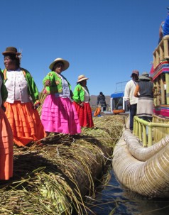
Woolen Goods, Colorful Blankets and Ponchos are on Sale
Here, Along With Miniature Reed Boats Like Those That
You Find in Lake Titicaca.
Puno is the point to Explore Titicaca with its Amazing
Array of Islands, Native Inhabitants and Colorful
Traditions. Small Motorboats Can be Hired for Trips on
the Lake or To Catchthe 13kg (30lb) Lake Trout That Make
it One of Peru's Best-Known Fishing Destinations.
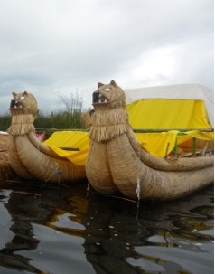
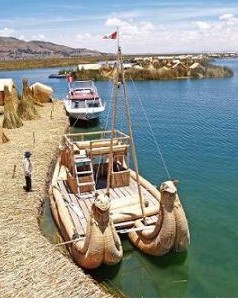
Most of the Transportation is Either by Motorized Small
Botes or the Totora Reed Boats That Norwegian Thor
Heyerdahl StudiedWhen Preparing For His Legendary 4,300-Nautical
Mile (7,970-km) and recreated the Journey From Peru to
Polynesia in the Reed Boat Kon-Tiki in the 1940s.
Floating Islands:
The Best-Known of the Titicaca Islandsare the Uros,
Floating Islands of Reed Named After the Natives Who
Inhabited Them. URI Uros "Which Means Untamed, Wild,
Brave, Indomitable Men, Clear and Wild, Came from an
Ethnic Group Called" QAPI "Whose Language was Pukina,
Which Became Extinct, Currently Uros Inhabitants Speak
Aymara. It is Also Said That They have Black Blood due
to Which They Could not Drown or Feel Cold in the Winter
Nights.
The Last Full-Blooded Uro was a Woman Who Died in 1959.
Other Uros Had Left the Group of Islands in Earlier
Years Because of the Drought That Worsen Their Poverty -
and Intermarried With Aymará and Quechua-speaking
Natives. But theNatives Who Now Inhabit This Islandis a
Mix of Uro, Aymara and Inca Descendants and Follow the
Uro Traditions.
The Uros' Poverty Has Prompted More and More and this
Made Them Move to Puno. That Same Poverty Has Made Those
Who Remain to Take a Hard-Sell Approach Upon Tourists
and, BesidesPressing Visitors to Buy Their Handicrafts,
They Frequently Demand "Tips" For Having Their
Photographs Taken.
Today, Tourism to the Uros Floating Islands is a Well-Oiled
Machine. Usually Combined With a One-Day Visit to the
island of Taquile, or a Two-Day Excursion to the Islands
of Amantani and Taquile, They Have Become the Most
Visited Destination on Lake Titicaca. They are a Close-knit
Group of islands, Built From Reed, That are Floating in
the Huili River, only 12 Minutes by Boat From the Port
of Puno. You are Dropped Off on 1 or 2 Islands, Where
Guides Explain How the Floating Islands are Built and
Maintained. Contrary to the Traditional Image of People
of the Plateau, the Inhabitants of the Uros Islands are
Quite Openhearted, Even Talkative; an Obvious Result of
the Place Tourism has Taken in Their Lives.
The Ancestral Grounds of the Uros are the Totora Reeds
That Occupy a Large Area of the Puno Bay. Due to its
Ecological Value, it is Part of the Titicaca Natural
Reserve, Which Forces an Uneasy and Sometimes Tense Co-Existence
Between Conservational Authorities and the People That
Went to Hide in Lake Titicaca so Nobody Could Rule Them.
But it Also Provides a Spectacular Background to An
Ancient Culture. Lake Titicaca has Over a Hundred
Endemic Species, Mainly Birds, but They Also Fish Like
the Ispi or Mauri, and is the Home of the Emblematic
Titicaca Flightless Greeb (Rollandia Microptera) or
“Zambullidor del Lago”. The Area is Bathed in Mysteries,
as it was Once Dry, Part of the Land and Apparently Host
to an Ancient Culture of Which Very Little is Known. The
HarborsArtificial Structures, Watersand Graveyards of
Which the Uros Only Whisper With Respect.
Handicrafts Also Play an Important Role in Life on
Amantani, a Lovely and Peaceful Island Even Further Away
From Puno Than Taquile. Amantani was Once Part of the
Inca Empire, as Shown by Local Ruins, Before the Spanish
Invaded and Slaughtered the Islanders. The Spaniard Who
Had a Concession to the Island Used the Indians in
Forced Labor andTheir Descendants Were Still in Control
After Peru's Independence From Spain. But Eventually an
Island Fiesta Turned Violent and the Indians Attacked
Their Landlord with Hoes and Consequently Split up the
Island into Communities Based on Plots
Amantani has Opened its Doors to Outsiders Who are
Willing to Live For a Few Days as the Aymará-Speaking
Islanders doand That Means Sleeping on Beds Made of Long
Hard Reeds and Eating Potatoes for Every Meal. There is
no Running Water or Electricity and at Nighttime
Temperatures Drop Down to Freezing Even in Summer. But
Those Who areHappy to go Through This Experience Catch a
Glimpse of an Andean Agricultural Community That has
Maintained the Same Traditions for Centuries. Some
Amantaní ResidentsLive and Die Without Ever Leaving the
Island.
Journeys to Amantaní Begin at the Puno Docks Aboard
Wooden Motorboats Operated by the Islanders. At the End
of the Four-Hour Trip, Visitors are Registered as Guests
and Assigned to a Host Family. The Family, Usually Led
by a Shy Patriarch, Shows the Way to its Mud-Brick Home
Set Around an Open Courtyard Decorated with White
Pebbles Spelling Out the Family's Name.
Another Island Well Worth Visiting is Amantani. It is
Very Beautiful and Peaceful, and in Many Ways Less
Spoiled than Taquile. There are Six Villages and Ruins
on Both of the Island's Peaks, Pacha Tata and Pacha
Mama, From Which There are Excellent Views. There are
Also Temples and on the Shore There is a Throne Carved
Out of Stone. The Residents Make Beautiful Textiles and
Sell Them Quite Cheaply at the Artensania Cooperative.
The People are Quechua Speakers, but Understand Spanish.
Electricity Supply From6-11pm.
Prepared Visitors Usually Bring Gifts of Fruit a Rarity
on the Isolated Island and the Socializing Begins When a
Family Member Who Speaks English Offers a Guided Walk
Around the Island, From Where the Views are Something
Spectacular. Women Wearing Traditional Black and White
Lace Dresses Pass by with Slingshots in Their Hands to
Kill Scavenging Birds.
Estevez is Another Island, it is Connected to Puno by a
Bridge and is Best Known by Tourist’s as IslaEstevez.
This Luxury Hotel is a Far Cry From What Used to be the
Main Construction on the Island a Prison That
Accommodated the Patriots Captured by the Spanish During
Peru's War for Independence.
James Orton, a Naturalist and Explorer Who Died Crossing
the Titicaca on a Steamship in 1877, is Buried on Isla
Estevez; His Memorial Sits Beside One Honoring the
Liberation Fighters who Perished in the War With Spain.
Orton, a Natural History Professor From Vassar
University, was on his Third Expedition to Explore the
Beni River in the Amazon Area. The Beni's Link to the
Mamore River Both Crucial Conduits During the Jungle's
Rubber Boom - was Named the Orton River in his Honor.
Mysterious Burial Chambers:
Some 35 km (21 Miles) From Puno is Sillustani, With
its Circular Burial Towers or Chullpas Overlooking Lake
Umayo. The Age of the Funeral Towers, Which are up to 12
Meters (40 Feet) High, Remains a Mystery. A Spanish
Chronicle-Keeper Described Them as "Recently Finished"
in 1549, Although Some Still Appear as if They Were
Never Completed and the Indians That Built Them Were
Conquered by the Incas About a Century Earlier.The
Chullpas Apparently Were Used as Burial Chambers for
Nobles of the Colla Civilization; These were Natives Who
Spoke Aymara, and Had Architecture knowledgeConsidered
More Complicated Than That of the Incas and Who Buried
Their Nobility with Their Entire Family.Not Far Away is
Chucuito, a Village That Sits Upon What was Once an Inca
Settlement and inWhich You Can See an Inca Sundial. Stop
by the Santo Domingo Church with its Small Museum in
This Plateau Village; Also Worth Visiting is La Asuncion
Church.
Juli, was Once the Capital of the Lake Area, Has Four
Beautiful Colonial Churches Under Reconstruction.
Although it NowAppears a Little Odd to See so Many Large
Churches so Close Together, at the Time the Spanish
Ordered Them Built They Hoped to Convert Huge Masses of
Natives o Roman Catholicism.
In Addition, the Spanish Were Used Having One Church For
the Europeans, One For the Mixed-Raced Christians and
Yet Another For the Natives. The Largest of Juli's
Churches is San Juan Bautista With its Colonial
Paintings Tracing the Life of its Patron, Saint John the
Baptist.
From the Courtyard of Church La Asuncion Visitors Have a
Captivating View of the Lake. The Other Churches in the
City are San Pedro, Once the City's Principal Place of
Worship and the Church in Which a Choir of 400 Natives
Used to Sing Each Sunday, and the Church of Santa Cruz,
Which is Just Beside the City's Old Cemetery. Santa Cruz
was Originally a Jesuit Church in the Front of Which
Natives Stonemasons Carved a Huge Sunthe Inca God Along
with More Traditional Christian Symbols.
Pilgrimage Site:
Copacabana Can Also beReached by Taking a Van Rid
Around the Side of the Lake, Passing the Reeds Waving
With the Wind, But You Can Always See Shy, Curious
Children at the Edges of the Road and Always the
Brilliant Blue of the Titicaca. This Pleasant Trip
Involves a Short Ferry Trip to the Tiquina Canal and the
Destination is a Nice One. Copacabana is a Friendly
Little Town Used to Tourists and Has a Number of Modest
but Clean Restaurants and Hotels. It is Most Famous For
its Cathedral Containing a 16th-Century Carved Wood
Figure of the Virgin of Copacabana, the Christian
Guardian of the Lake.The Statue, Finished in 1853, was
the Work of Indian Sculptor Francisco Tito Yupanqui,
Nephew of Inca Huayna Capac. During Mass, the Statue
Stands With its Back to the Congregation - but Facing
the Lake so it Can Keep an Eye on Any Approaching Storms
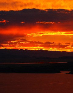
and Earthquakes.One of the Best Things in Copacabana is
a Dawn or Dusk Walk Along the Waterfront, Watching the
Sky Explode into Colors With the Sunrise or Slip into
the Blue Black of Night at Sunset.
From Copacabana, Boats Can be Hired to Visit the
Bolivian Islands Which are Also on Lake Titicaca the
Island of the Sun and the Island of the Moon. The Island
of the Sun (also Accessible Through a Public Ferry) has
a Sacred Inca Rock at One End and the Ruins of Pilko
Caima With a Portal Dedicated to the Sun God at the
OtherEnd. The Island of the Moon, Which is Also
Sometimes Called Coati, has Ruins of an Inca Temple and
a Cloister for Chosen Women.
|